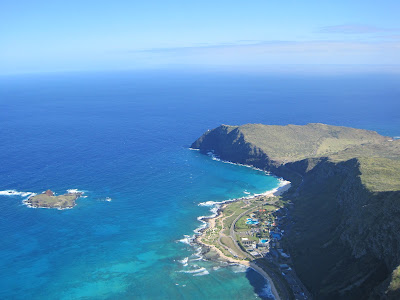
We met at Dave’s house and loaded up the gliders. His prediction was for 25mph on launch. “Oh great…” I thought. It’s no secret that windy conditions stress me out, and this launch seemed particularly intimidating in strong winds. But I figured I would go up there and check it out. I could always chicken out and just watch Dave and another pilot, Dale, fly.
On launch we found the SE flow was being partially blocked by the peak to the South, and was wrapping around slightly. So what we saw coming up the face was ~15mph, ranging from 10 to 20+. It looked fine to me and I was eager to launch. I watched Dave again and this time Dale assisted me at launch. Same routine as before, but this time with more wind. One step to get an aggressive launch and I was off again.
 Soaring with Dave
The air was big and phat. P-H-A-T! I quickly climbed high up over launch as Dave chased me around the sky trying to get some good video shots. After a short while I flew a ways out over the ocean to get some shots of my own. Wow!
 Looking SE From High Over the Water
 Rabbit Island. I liked watching the waves wrap around the island.
 NorthWest From Out Over the Bay
Dale launched on a crispy new T2 and he and Dave flew South to play around the lighthouse and low in the bowl over SeaLife Park. I stayed high cruising several miles of ridge from the lighthouse back to North of launch. I wanted to buzz some parts of the ridge, but the lift was intense near the hill and the bar pressure on the Horizon was enormous. So I contented myself with flying around high, cruising out over the ocean, and generally drifting lazily through the sky. The strong SE wind did put us downwind of Rabbit Island which did through off the occasional (and surprising) bit of nasty turbulence. I got hit by it 2 or 3 times and it always caught me off guard because the air was otherwise so smooth and nice. It reminded me a bit of Waddell actually, except I was having fun…
 Over The Back
 Military Heli Over Rabbit Island
 I Really Liked the Two Pointy Peaks by Kailua
I spent more of this flight at the SE end of the island. Dave and Dale were playing around low in a bowl below me (want to try that next time). I cruised out around the lighthouse and over the shallow bay next to it. There is a ton of helicopter traffic on the island. Lot’s of sight seeing tours, and a good number of military copters as well. I assume they know the area is frequented by hang gliders and paragliders, but I kept a constant eye out and always tried to show a sunny undersurface to any that I saw.
 Another View of the LZ
 Dave and Dale Playing Low in a Cove, SE of the LZ
 Lighthouse at the SE Tip of the Island
 Looking Back to the North From the SE end of the Island
A little more than an hour after I launched I decided it was time to head in and show off for my family who were watching in the LZ. I burned off some altitude circling over the water and set up a similar approach as the day before. Low over the parking lot and touching down smoothly about midway in the LZ. Smiles, cheers, and beers were soon to follow and I instantly started sorting out how I could get back there again.
Flight Time: 1:12


1 comment:
Phenominal views! your altitude made the cliffs look small. How high were you?
Post a Comment